-
Kathmandu
-
Kathmandu
-
Strenuous
-
Solukhumbu
-
Adventure/Active
-
12+
-
Private and Group
-
Fully Guided
-
Instant Booking
-
5364 m
-
March-May and Sep-Nov
Overview
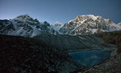
One of the most breathtaking vistas in Nepal are the Gokyo Lakes, with their crystal clear, emerald green and blue waters. They make up the world’s highest network of freshwater lakes, located at an average altitude of about 5,000 meters. If you want to hike in the Everest region but prefer not to spend too much time at extreme altitude, the Gokyo Lakes trip is a great option.
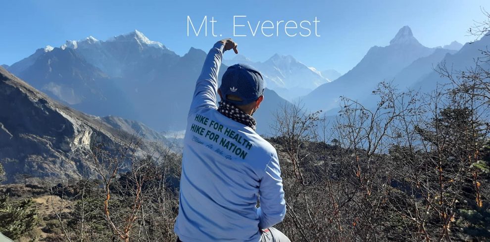
There is a lot to see on this trek, from the vivid turquoise high-altitude lakes to the Ngozumpa glacier (the largest glacier in the Himalayas) and vistas across to Everest and other 8,000-meter-plus mountains from the top of Gokyo Ri (Lhotse, Makalu, and Cho Oyu). Gokyo Lake is well-known for its incredibly clear blue and green water. Gokyo Lake is a popular destination for tourists who wish to cut down on their trekking time in Nepal’s renowned Everest region. The Gokyo Lakes Walk offers the finest view of the Everest Himalaya, including Mt. Everest, of any trek in the area.
There is a lot of natural beauty along the paths to Gokyo. During your travels, you’ll encounter a wide variety of ecosystems, from the dry, arid highlands to the tropical lowlands, dense rainforests to rolling green hills to snowy, parched plains. As you stroll, you’ll experience the diverse landscape. The sight of the towering Himalayas as you stroll through them may do wonders for your spirit. Trekking through the Dudh-Kosi River, a rushing river surrounded by stunning glaciers, is another highlight of this adventure. Additionally, Sagarmatha National Park is home to an abundance of flora and fauna.
Gokyo Lake Trekking Highlights
- Gokyo-RI is the highest viewpoint of trekking.
- It is considered an alternative trek to the Everest Base Camp.
- Gokyo trekking is hiking through the Dudh Pokhari and Ngozumba glacier.
- Ngozumba glacier is the largest glacier in Nepal.
- The trails offer wonderful views of the Glacier, Sherpa culture, and Himalayan Lakes.
Itinerary
Today we will take a wonderful flight from Kathmandu to Lukla (2827m). After 40 minutes, we will land on a runway and our caretaker will help us carry our belongings. Then we will walk down to the Dudh Koshi River, where we connect with the main path to Namche Bazaar.
After moving all the way through the small area of Ghat (2550m), we will soon arrive at our tea house at Phakding. Overnight at tea house.
Special Note:
The weather in Lukla is highly unpredictable. The small airstrip, located on top of a hill with mountains surrounding on three sides, is widely known for terrible weather, which impacts the regular flight schedules. The flights, in such circumstances, may likely be delayed or even canceled in worst cases
The transportation back to the hotel and accommodation on this night is not included. You will have to pay additional for this yourself. If the weather is clear the next day, you will get either the 3rd or 4th flight to Lukla.
On this day, you will pass through several small villages and cross over the Dudh Kosi river several times on suspension bridges. You will also have the opportunity to visit the famous Hillary Suspension Bridge, named after Sir Edmund Hillary, who was one of the first climbers to reach the summit of Mount Everest.
As you continue on the trek, you will enter the Sagarmatha National Park, a UNESCO World Heritage Site that is home to a variety of flora and fauna, including musk deer, Himalayan black bear, and the Himalayan monal, a colorful pheasant found in the region.
After around 6-7 hours of hiking, you will reach Namche Bazaar, a bustling town that is the administrative and business center of the Khumbu region. Namche Bazaar is also known for its Saturday market, where local farmers and traders come to sell their goods.
The trek from Phakding to Namche Bazaar is relatively easy, with a gentle ascent and a total distance of around 10 kilometers (6 miles). It is a good introduction to the higher altitudes of the Everest region and a great way to acclimatize to the thinner air.
The acclimatization day in Namche Bazaar is a chance for trekkers to rest and take it easy after the first few days of trekking.
On the acclimatization day in Namche Bazaar, you can take a short hike to one of the nearby viewpoints, such as the Syangboche Airport or the Namche Museum. The airport is a short and easy hike that offers panoramic views of the surrounding mountains, including Ama Dablam and Thamserku. The Namche Museum is a small museum that displays the culture and traditions of the Sherpa people, as well as the history of the region.
You can also take the opportunity to explore the town of Namche Bazaar and visit the local market, where you can find a variety of goods, including traditional handicrafts and souvenirs. Namche Bazaar is also home to several restaurants and cafes, where you can relax and try some local cuisine.
It is important to remember that on the acclimatization day, you should not push yourself too hard and should allow your body to rest and adjust to the altitude. It is also a good idea to stay well hydrated and to drink plenty of water to help your body acclimatize.
Namche bazar to Dole trek involves a total distance of approximately 12 kilometers (7.5 miles) and a total ascent of approximately 1,000 meters (3,280 feet). The trek starts with a descent from Namche Bazaar to the Dudh Kosi river, followed by a steep ascent to Phortse Tenga. From Phortse Tenga, the trail continues through a forest and then opens up into a clearing with views of the surrounding mountains.
After a short descent, the trail then climbs again to Mong La pass (3,700 m), which offers panoramic views of the mountains and valleys below. From Mong La, it's a relatively easy descent to Dole, which is a small village located in the Khumbu region of Nepal. Dole has a few tea houses and lodges where trekkers can spend the night.
The total trekking time from Namche Bazaar to Dole is typically around 5-6 hours, depending on your pace and the number of breaks you take. The trail is well marked and there are plenty of tea houses and lodges along the way where you can rest and have a meal. As always, it's important to pace yourself and listen to your body to avoid getting fatigued or altitude sickness.
Dole to Machhermo trek involves a total distance of approximately 11 kilometers (6.8 miles) and a total ascent of approximately 740 meters (2,427 feet). The trek starts with a descent from Dole to a bridge over the Dhudh Koshi River. After crossing the bridge, the trail begins a steep ascent through forests and pastures to Luza (4,360 m).
From Luza, the trail continues to climb through a valley, passing several small villages and fields of wheat, potatoes, and buckwheat along the way. After a short descent, the trail then climbs again to a ridge and then descends to Machhermo, a small village located in the Khumbu region of Nepal. Machhermo has a few tea houses and lodges where trekkers can spend the night.
The total trekking time from Dole to Machhermo is typically around 5-6 hours, depending on your pace and the number of breaks you take. The trail is well marked and there are plenty of tea houses and lodges along the way where you can rest and have a meal.
Machhermo to Gokyo trek involves a total distance of approximately 8 kilometers (5 miles) and a total ascent of approximately 320 meters (1,050 feet). The trek starts with a gentle ascent from Machhermo, passing through fields and forests of fir, rhododendron, and juniper.
As you continue to climb, you will pass several small villages and tea houses, and the views of the surrounding mountains and valleys will become increasingly expansive. After about 3-4 hours of trekking, you will reach Gokyo, a small village located in the Khumbu region of Nepal. Gokyo is located near the base of the Ngozumpa Glacier and is known for its stunning views of the surrounding mountains, including Cho Oyu, the sixth highest mountain in the world.
Gokyo has a few tea houses and lodges where trekkers can spend the night. The total trekking time from Machhermo to Gokyo is typically around 4-5 hours, depending on your pace and the number of breaks you take. The trail is well marked and there are plenty of tea houses and lodges along the way where you can rest and have a meal.
Day 8 of the Gokyo Lake trek is a rest day in Gokyo, which is a great opportunity to acclimatize and explore the village and surrounding area. Gokyo is located at an altitude of 4,790 meters (15,715 feet) and is known for its stunning views of the surrounding mountains, including Cho Oyu, the sixth highest mountain in the world.
One of the highlights of a rest day in Gokyo is a visit to Gokyo Ri (5,360 meters/17,590 feet), a small peak located above the village that offers panoramic views of the surrounding mountains and valleys. To reach Gokyo Ri, you will need to hike for about 2-3 hours from the village, depending on your pace. The trail to Gokyo Ri is steep and challenging, but the views from the top are well worth the effort.
On a rest day in Gokyo, you can also visit the nearby Ngozumpa Glacier, which is the longest glacier in the Nepal Himalayas. The glacier is located about 1.5 hours from Gokyo and can be reached by a combination of hiking and boat ride. Alternatively, you can spend the day exploring Gokyo village and relaxing in your guesthouse.
It's important to keep in mind that a rest day in Gokyo is not a complete day of rest and you should still try to stay active to help with acclimatization. You can do this by taking short walks around the village, practicing yoga or other light exercises, or simply by stretching and breathing deeply to help your body adjust to the altitude. As always, it's important to listen to your body and take it easy if you are feeling tired or unwell.
Day 9 of the Gokyo Lake trek is a moderate to challenging day of trekking that involves a total distance of approximately 8 kilometers (5 miles) and a total ascent of approximately 310 meters (1,020 feet). The trek starts with a descent from Gokyo to the Gokyo Lakes, a series of freshwater lakes located in the Khumbu region of Nepal. The Gokyo Lakes are considered sacred by the local Sherpa people and are known for their stunning blue-green color.
After exploring the Gokyo Lakes, the trail continues to climb through a valley, passing several small villages and fields of wheat, potatoes, and buckwheat along the way. After about 3-4 hours of trekking, you will reach Thangna, a small village located at an altitude of 4,700 meters (15,420 feet). Thangna has a few tea houses and lodges where trekkers can spend the night.
The total trekking time from Gokyo to Thangna is typically around 4-5 hours, depending on your pace and the number of breaks you take. The trail is well marked and there are plenty of tea houses and lodges along the way where you can rest and have a meal.
Thangna to Dzongla trek involves a total distance of approximately 10 kilometers (6.2 miles) and a total ascent of approximately 630 meters (2,070 feet). The trek starts with a descent from Thangna to a bridge over the Ngozumpa Glacier. After crossing the bridge, the trail begins a steep ascent through a valley, passing several small villages and fields of wheat, potatoes, and buckwheat along the way.
As you continue to climb, you will pass through a forest of rhododendron, fir, and juniper, and the views of the surrounding mountains and valleys will become increasingly expansive. After about 4-5 hours of trekking, you will reach Dzongla, a small village located in the Khumbu region of Nepal. Dzongla is located at an altitude of 4,830 meters (15,860 feet) and has a few tea houses and lodges where trekkers can spend the night.
The total trekking time from Thangna to Dzongla is typically around 4-5 hours, depending on your pace and the number of breaks you take. The trail is well marked and there are plenty of tea houses and lodges along the way where you can rest and have a meal.
Day 11 of the Gokyo Lake trek is a moderate to challenging day of trekking that involves a total distance of approximately 11 kilometers (6.8 miles) and a total ascent of approximately 880 meters (2,890 feet). The trek starts with a steep ascent from Dzongla, passing through a valley and a forest of rhododendron, fir, and juniper. As you continue to climb, you will pass several small villages and fields of wheat, potatoes, and buckwheat, and the views of the surrounding mountains and valleys will become increasingly expansive.
After about 5-6 hours of trekking, you will reach Lobuche, a small village located in the Khumbu region of Nepal. Lobuche is located at an altitude of 4,910 meters (16,110 feet) and has a few tea houses and lodges where trekkers can spend the night.
The total trekking time from Dzongla to Lobuche is typically around 5-6 hours, depending on your pace and the number of breaks you take. The trail is well marked and there are plenty of tea houses and lodges along the way where you can rest and have a meal.
Today we cover a total distance of approximately 8 kilometers (5 miles) and a total ascent of approximately 250 meters (820 feet). The trek starts with a gentle ascent from Lobuche, passing through a valley and a forest of rhododendron, fir, and juniper. As you continue to climb, you will pass several small villages and fields of wheat, potatoes, and buckwheat, and the views of the surrounding mountains and valleys will become increasingly expansive.
After about 3-4 hours of trekking, you will reach Gorak Shep, a small village located in the Khumbu region of Nepal. Gorak Shep is located at an altitude of 5,160 meters (16,930 feet) and has a few tea houses and lodges where trekkers can spend the night. From Gorak Shep, you can visit the Pumori Base Camp, which is located at an altitude of 5,400 meters (17,700 feet) and offers panoramic views of the surrounding mountains and valleys.
The total trekking time from Lobuche to Gorak Shep is typically around 3-4 hours, depending on your pace and the number of breaks you take. The trail to the Pumori Base Camp is a round-trip of about 4-5 hours, depending on your pace and the number of breaks you take. The trail is well marked and there are plenty of tea houses and lodges along the way where you can rest and have a meal.
Day 13 of the Gokyo Lake involves a hike to Kala Patthar (5,545 meters/18,192 feet) and a trek to Pheriche (4,240 meters/13,910 feet). Kala Patthar is a small peak located near the base of Mount Everest that offers panoramic views of the surrounding mountains and valleys. The hike to Kala Patthar is steep and challenging, but the views from the top are well worth the effort.
To reach Kala Patthar, you will need to start from Gorak Shep, a small village located in the Khumbu region of Nepal. From Gorak Shep, it takes about 3-4 hours to hike to Kala Patthar, depending on your pace and the number of breaks you take. After reaching the summit of Kala Patthar, you will then return to Gorak Shep and have lunch before continuing your trek to Pheriche.
The trek from Gorak Shep to Pheriche is a moderate to challenging day of trekking that involves a total distance of approximately 14 kilometers (8.7 miles) and a total descent of approximately 920 meters (3,020 feet). The trek starts with a gentle descent through a valley and a forest of rhododendron, fir, and juniper. As you continue to descend, you will pass several small villages and fields of wheat, potatoes, and buckwheat, and the views of the surrounding mountains and valleys will become increasingly expansive.
After about 6-7 hours of trekking, you will reach Pheriche, a small village located in the Khumbu region of Nepal. Pheriche is located at an altitude of 4,240 meters (13,910 feet) and has a few tea houses and lodges where trekkers can spend the night.
The total trekking time from Gorak Shep to Pheriche is typically around 6-7 hours, depending on your pace and the number of breaks you take. The trail is well marked and there are plenty of tea houses and lodges along the way where you can rest and have a meal.
Day 14 of the Gokyo Lake trek is a moderate day of trekking that involves a total distance of approximately 17 kilometers (10.6 miles) and a total descent of approximately 800 meters (2,620 feet). The trek starts with a gentle descent from Pheriche, passing through a valley and a forest of rhododendron, fir, and juniper. As you continue to descend, you will pass several small villages and fields of wheat, potatoes, and buckwheat, and the views of the surrounding mountains and valleys will become increasingly expansive.
After about 6-7 hours of trekking, you will reach Namche Bazaar, a small village located in the Khumbu region of Nepal. Namche Bazaar is located at an altitude of 3,440 meters (11,290 feet) and is known for its traditional Tibetan-style houses and its vibrant Saturday market. Namche Bazaar has a few tea houses and lodges where trekkers can spend the night.The total trekking time from Pheriche to Namche Bazaar is typically around 6-7 hours, depending on your pace and the number of breaks you take.
The return trek from the Everest Base Camp continues along the Dudh Koshi River to the small mountain airstrip at Lukla where you will catch your return flight to Kathmandu.
Amazing scenic fly back to Kathmandu. It’s better to consider this day as buffer day too as just in case flight did not take off due to bad weather condition.
Includes/Excludes
Includes
- Airport pickup and drop by car/van/bus
- TIMS cards
- Entry permit
- Meals during trek (breakfast/lunch/dinner)
- Experienced local guides and porters
- All accommodation during the treks
- Medical supplies (first aid kit) with regular check up of oxygen saturation
Excludes
- Any food, deserts and accommodation during your stay in Kathmandu.
- Travel medical insurance and emergency evacuation cost.
- Nepal entry visa fee and International air fare.
- Personal equipment.
- Tips for guide and Porter (Tipping is expected)
- Personal expenses such as: Alcoholic beverages, hot shower, water bottle, cold drinks, hot water, battery charge and donation. etc.
- Extra night food and accommodation due to any reason.
- Any other expenses which are not mentioned on ‘price included’ section
FAQs
For a hike of this duration at such a high altitude, this one is regarded relatively easy. If you take a hike up to Gokyo Ri, you will reach an elevation of about 5,400 meters at the peak. Since Gokyo Ri’s peak sits at almost the same elevation as Everest Base Camp, the altitude-related difficulties associated with this hike are less severe. However, you won’t spend a single night over 4000 meters, so there’s no need to worry about altitude sickness; in fact, this trek has fewer nights spent above that mark, and it’s not nearly as strenuous.
The entire hike is on a well-worn trail, albeit it is rocky and rough in spots. It’s not cliffy, and there’s no equipment-required rock climbing or “mountaineering.” All of it is a walk, though some of the hills seem to go on forever.
You’ll be on your feet for six or seven hours a day, and the trail will rise and fall as it passes through various side valleys and high mountain passes. That’s why it’s important to be healthy and physically active before setting out on this hike. Doing aerobic activity like walking or running before a trip to the high-altitude Gokyo Lakes is a terrific idea.
Most people go on a trek to Gokyo lake in the fall (September, October, and November). During Autumn, you can trek to Gokyo lakes with favorable weather and temperature. Not to mention, the scenery in the area is beautiful.
The months of March, April, and May are the next best time to hike to Gokyo lake. The weather won’t change much during this window. At the same time, the weather at higher altitudes will continue to be agreeable for hiking.
Avoid hiking in the winter and summer. Due to the ever-changing nature of Everest’s climate, these times see fewer visitors. In order to successfully complete a trip across the Gokyo valley outside of the peak seasons, you will need to put in a lot of work in preparation.
Both Buddhists and Hindus revere Gokyo Lake as a holy site, and every year on Janai purnima, over 500 Hindus visit the lake to bathe in the holy water. Located at the lake’s westernmost point is a temple dedicated to Hindu gods such as Vishnu and Shiva. Visitors come to pay their respects to Naag Devata, who is believed to live there. Wetland birds are protected by the lake because people believe there would be “no harm” done to them there.
An additional aspect of the journey is learning about the Sherpa people and experiencing the friendly hospitality of the locals. People are keeping centuries-old cultures and traditions alive by building religious monuments (monasteries, chortens, lanes, and boundary walls) and cultural landmarks (museums).
The town of Gokyo is at an impressive 4750 meters in elevation. In this town, yak herds are typical sights. The Gokyo lakes are a set of freshwater lakes revered by the locals as a sacred spot. The settlement of Gokyo sits on the third lakeside of the six lakes that make up the Gokyo valley.
The area around Gokyo Lake, with its glaciers and fauna, is the best trip one can do while staying in the village of Gokyo. Some of the other sights that may be seen on a Gokyo valley trip include chortens, rural monasteries, compass, and settlements of the famed Sherpa people.
In addition to the village of Gokyo, well-known settlements such as Machhermo and Dole will provide opportunities to acclimate along the course of the walk.
At higher altitudes, a tundra-like association of short grasses, sedge mosses, and alpine plants may take over from rhododendron, juniper scrub, and other procumbent woody vegetation.
Himalayan marmots, mouse hares, tahrs, musk deer, snow leopards, and even blue sheep are the only plausible mammalian species to be found there. Wild Yak and huge Tibetan sheep were once commonly seen in this area, and it’s conceivable that some remain in remote locations like Dolpa and Humla. The abundant avian life includes species like the lammergeyer, snowcock, snow partridge, chough, and bunting, with redstarts and dippers commonly spotted in the water.
Only yaks can tolerate the extreme heights found in the Himalayas. They’re useful for hauling and packing. The Sherpas rely on the female Yak for milk. Cheeses made from the milk can be safely consumed for a long time.
Because of its abundance and variety of plant and animal life, Nepal is a veritable paradise for those interested in nature and wildlife.
Recommended Gears for the Trek
The Gokyo Lake Trek can be appropriate and pleasant if you are geared up with a proper packing list. Therefore, being prepared with the packing list prior to the trek comes in handy.
The necessary packing list for the trek are mentioned under the following points:
Clothing
- Jackets (Windproof or Down)
- Waterproof outerwear
- Thermal wears
- Woolen hat or cap
- Pair of gloves
- Shoes
- Tracksuits and trouser
- Trekking boot
- Towel
Equipment
- Bags
- Sunglasses and sunscreen
- Water bottle
- Camera, binocular and mobile phones
- Extra batteries or power bank
- Water purifier tablets
- Headlamp and torch
- Trekking Sticks
- Lighters
- Whistle
- Toilet papers and tissue papers
Conclusion
The lake at 5360 meters above sea level, Gokyo Ri, is the main attraction here. Gokyo ri summit has the finest view of Everest. The Himalayan area of Nepal, which stretches across the planet’s very top, is without a doubt one of the planet’s most spectacular travel locations. It’s not easy to find a location where you can have a sense of being one with the stars, much less one where you can go on a multi-day walk that will alter your life in profound ways.
Trip Reviews
There are no reviews yet. Be the first one to write one.
Write a Review
Your email address will not be published.


