-
Kathmandu
-
Kathmandu
-
Manaslu, Gorkha
-
Strenuous
-
Adventure/Active
-
12+
-
Private and Group
-
Fully Guided
-
Instant Booking
-
5135 m
-
5135m
-
Carbon Neutral
Overview
Manaslu is the world’s eighth-highest peak at 8,156 meters (26,758 feet), and the incredible walk there takes you through some stunningly magnificent vistas, roaring white-water river falls, and thick forests on the way to the summit.
After opening in 1992, the Manaslu Trek quickly gained in popularity due to its allure and the pristine beauty of its natural setting. The route takes us into the borderlands between Nepal and Tibet, where we may get a taste of the Hindu and Buddhist cultures. The uncharted paths lead us through lush forests brimming with rhododendron, pine, cedar, birch, and juniper trees, as well as enchanting meadows.
Manaslu, at 8,156 meters (26,758 feet), is the eighth highest peak in the world, and it can be circumnavigated on the Manaslu Walk, a tea house trek. Hindu and Buddhist culture, lovely fauna, rhododendron and other blossoms, roaring rivers, hazardous bridges, enormous mountains, and stunning scenery are all hallmarks of other Nepali treks, and these may be found on this one as well.
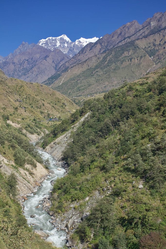
Through the powerful Budhi Gandaki valley with its turquoise streams and stunning waterfalls, the circuit leads you from the hot lowlands with their terraced rice and millet fields. A large number of very tall and frequently very long suspension bridges will be traversed throughout the course of the journey.
Highlights of Manaslu Circuit Trek
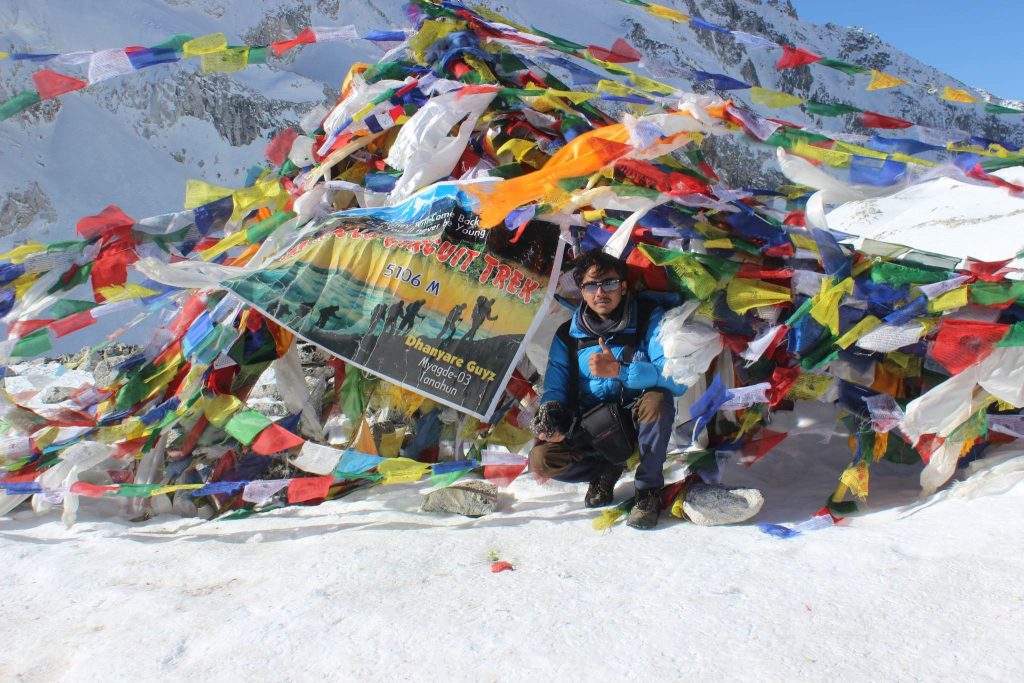
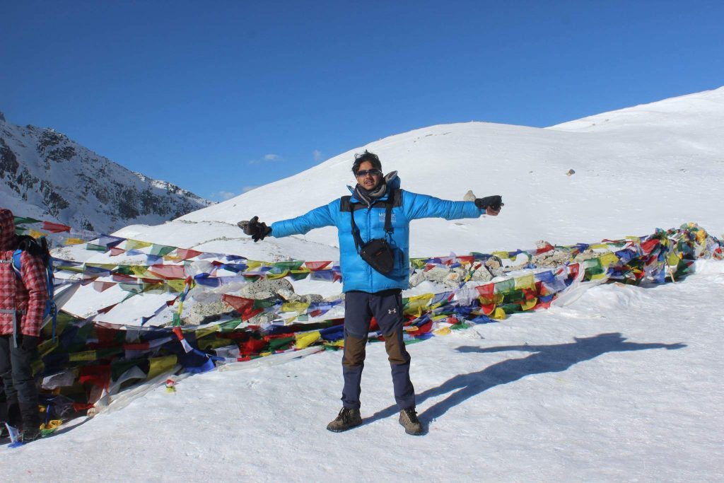
- Cross one of the highest passes in the world at Larkya La Pass at 5,106 meters
- Spot wildlife species of Tahr (mountain goat), Agali (Blue Sheep), Pika (Highest Living Mammal), Himalayan Marmots, and even Snow Leopard
- Spectacular panoramas of Manaslu, Cheo Himal, Ganesh Himal Range, Himlung Himal, Lamjung Himal, Nemjung, Gyaji Kang Guru, and Annapurna II
- One of the popular restricted trekking regions with high altitude glacial lakes; four glaciers are mingled above Lamjung Himal
- Soak into the lifestyle and culture of Nuri, ethnic habitant of the region
- Explore the fascinating Tibetan influenced culture and festivals celebrated by Indo-Aryan Hindus like Magar, Gurung, Tamang, Burmese.
- Rich in local multi ethnic biodiversity and natural scenery with captivating of Manaslu Conservation Area
- Trails pass-through several farmlands; Budhi Gandaki River Gorge, forests of rhododendrons, oak, pine, bamboo, cedar, birch, juniper, and delightful meadows
Itinerary
Today, you will head out to the starting point of your trek i.e. Solti Khola. You will take a bus from Kathmandu to Soti Khola. The route of the bus takes you along the Prithvi Highway towards Dhading Besi. A further 35-kilometer drive leads you to Arughat. As the road gets winding up to Gola Bhanjyang, you can see panoramic views Ganesh, Baudha and Manaslu Himal. A further 3 hours of ride leads you to Soti Khola. The bus ride up to Soti Khola is 8-9 hours. You will stay overnight at Sotikhola (710 metres)
This is the first day of your trek. You pass through forests, rice paddies, a cliff-face ridge, a rushing river, and several beautiful waterfalls.From there, you trek to ‘Khursani Baari’ which translates to ‘field of chilies’ where you will see a 100m waterfall.From here, you keep walking to ‘Machha Khola’ which translates to ‘river with fish’. Here, you will find around 20-30 local houses with 4 popular hotels.You will stay overnight at a lodge in Machha Khola(900 metres).
After breakfast, you will head out on a 6-7 hour trekking journey to Jagat (1410 meters). After crossing Machha Khola, you will trek gently up to the tiny village of Khorla Bensi. From there, you will get to the natural hot springs at Tatopani. This trail is also quite challenging.
After crossing a short forested path, you will reach a single teahouse at Doban. Above the village of Dobhan, Budhi Gandaki river descends rather impressively to a series of rapids. The river is quite calm beyond this steep slope. A further trek from Dobhan leads you to Lauri, where you will cross the river on a suspension bridge. Finally, you will climb on a high path to the fields of Jagat (1410 metres), where you will spend your night.
You make your way to Upper Jagat and Salleri. You will notice two hydropower plants on the way.From Salleri, you continue on to Sirdibas with views of Mt. Siring (7,239m). Then you reach Philim. From Philim, you will trek through Chisapani, Ekle Bhatti, Nayak Phedi, and Pewa. Most of these are beautiful, quaint and small villages.In Pewa, you will cross two suspension bridges. From here, it is a 45-minutes walk to Deng.
Overnight stay in Deng(1340 metres).
Deng is a village that is the point of entry to Kutang or lower Nupri (part of Tibet until the 1840s): It is a primarily a Gurung settlement with the culture of Tibetan Buddhism. They have their own language. The trail from Deng takes you along a winding path to Rana. After trekking past a series of uphills and downhills, you will get to a log bridge. After crossing a tributary from the bridge, you will get to an isolated water mill. Then you will descend gently along the trail to Bihi Phedi, which lies high above the river.
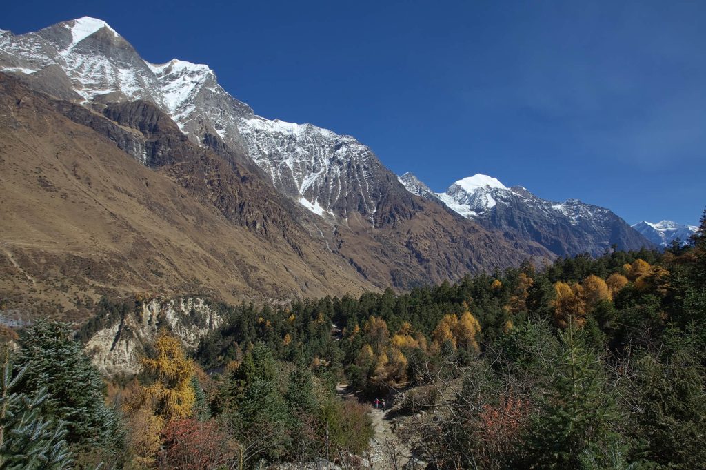
Beyond Bihi Phedi, the trail descends as you cross the Serang Khola. Then, you will trek along a winding path that shapes up like an S. The path lies between sheer basalt walls. You can also see huge rocky crags to the right. You will also have splendid views of the waterfall above the maize and wheat fields. As you trek towards the northeast direction, the valley broadens. After trekking past a bridge and mani stone walls, you will reach the attractive village of Ghap (2,250m/ 7,382ft). Past the village of Ghap, you will trek through bamboo, rhododendron and oak forests. On some days, you can also see birds like Impeyan pheasant (also known as Himalayan Monal)
This trail is above the steep descent of the river. For a short duration of time, you will trek to the north bank. Then you will head back towards the southern bank after crossing a bridge. After trekking for one hour from the bridge, you will reach Namrung. Namrung also has a police checkpoint for permits. Just before you get to Namrung, the trail overlooks Tum Khola from Tibet. This adds to the volume of water in Budhi Gandaki in the confluence. The trek from Deng to Namrung (2900 meters) is 6-7 hours long.
Overnight stay at Namrung (2900 metres)
Your trek to Samagaon takes you through places like Banjam, Lihi, Sho, Lho, and Sayla.
Once you leave Namrung, you enter the Upper Nupri region. Here, the local dialect changes to a form of Tibetan style. The locals can be seen in Tibetan style dresses like chubas- the Tibetan style of wrapping around cloak.
On this day, you will also cross the Budhi Gandaki river, walk through the alpine forests, stone arch, Chortens, and barley terrace fields.
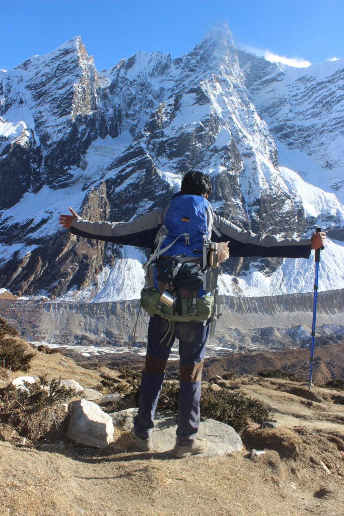
Once you cross the Hiran Khola, you can get a spectacular sight of Mt. Manaslu, Manaslu North (7,157m) and Naike Peak (5,515m).
Lho is where you will rest and have your lunch. If time permits, you can explore the Buddhist monastery and also enjoy the great views of the Himalayas.
From here, you will trek downhill the steep path to Lihi. Upon reaching Syala, you will get the panoramic views of Himalchuli, Nadi Chuli Manaslu, Saula Himal, and Siringi Himal. Syala is also where you will get to see a real yak. Syala is also one of the biggest villages of the region and a popular place for commerce.
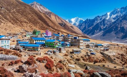
Overnight stay at the beautiful village of Samagaon (3500 metres).
Today, you will explore the village of Samagaon, which is the regional center of Nupri. You will also get to know about the culture and architecture in the region: only potatoes and barley flourish in the short summers at this altitude. Most of the people in this village weave clothes from sheep or Tibetan imported wool. They are also involved in the manufacture of hooked rugs for trade with Tibet.
You will visit the Labrang (Lama’s Place) Gompa and the Kargyu Chholing Monastery in Samagaon, The history of these monasteries dates back some 500 years ago. Many people ascribe the history of these monasteries to its earlier Tibetan settlers. The monastery has impressive wooden carvings. All in all, there are eight temple buildings. The largest of them is the Pemba Chholing Gompa. It is home to an impressive statue of Guru Rinpoche.
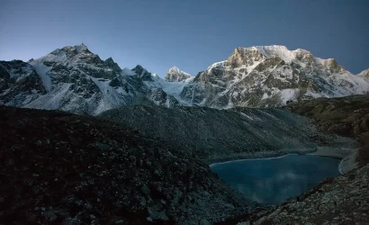
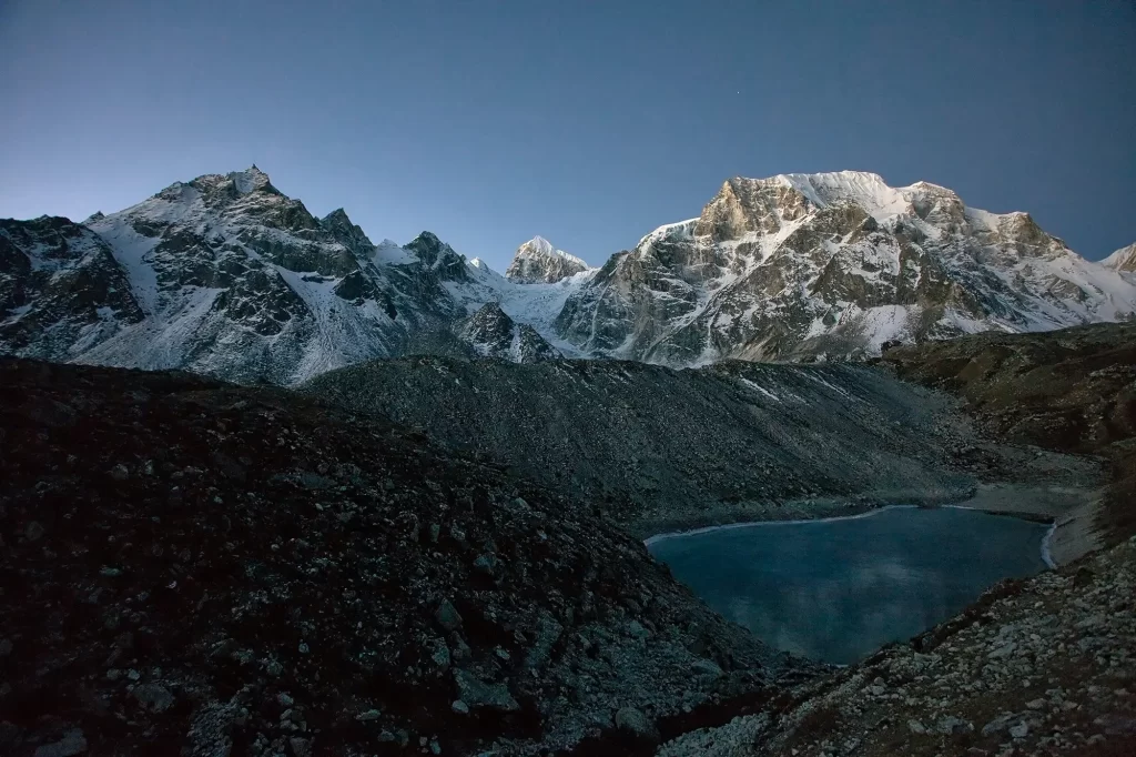
A gentle hike past the monastery leads you to Birendra Tal (3,450m/11,319ft). This lake lies below Manaslu Glacier. You can also trek for close to 3 kilometers to get to a hilltop or a stony beach which offers wonderful views of Manaslu. You can also follow a trail towards Samdo to a bridge over the stream from the lake. After trekking for 5-6 hours, you will get to Manaslu Base Camp.
You can also trek to Pungyen Nunnery (3,870m/12,697 ft). It lies above Pungyen Glacier. You can get sumptuous views of the Nadi ridges and Manaslu from near the gompa.
Overnight stay at Samagaun(3500 metres)
On the 9th day, you begin your trek with a walk across a hill for around 2 hours. This hill is a ledge above the river.
It is also the grazing area of blue sheep. You may see some on the barren hillsides. On this path, you will walk through beautiful juniper and birch forests. Samdo is at the junction of the 3 valleys. Samdo village (3,800m) is a Tibetan refugee village. This village has its own hydropower project, therefore it has an uninterrupted supply of electricity.
If you are up for it, go for a hike to the viewpoint in Samdo. It is around 1.5 to 2 hours walk from the village. It offers fabulous views and is a great way to acclimatize as well.
Some of the mountains you can see from here are Mt. Manaslu, Samdo (Pang Phuchuli), Ngadi Chuli, Simnang Himal, and several other mountain peaks. Along with these, you can also see Manaslu glacier and Manaslu icefall.
You will stay overnight at Samdo village(3690 metres).
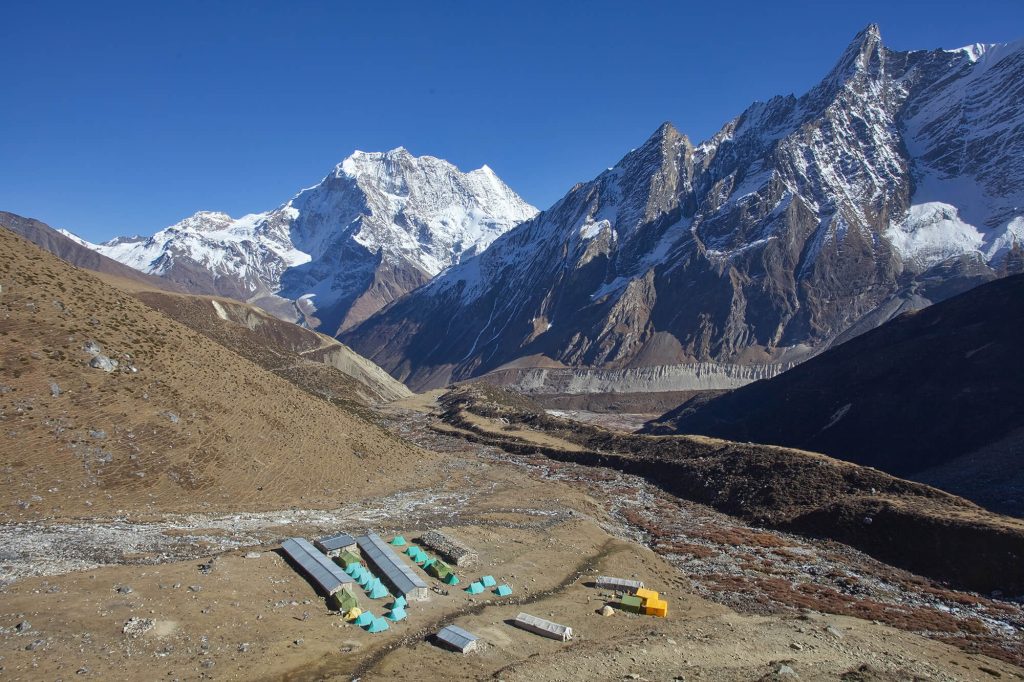
The day starts with a downhill trek to the Budhi Gandaki river. You will then cross the river and start your climb upwards through Larkya Bazaar and the valley of Salka Khola to Dharamsala.
Also known as Larkya Phedi, Dharamsala is a seasonal village. It has a little shelter house that provides room for trekkers. On the way, you will come across the magnificent Larkya Glacier. You can roam and explore the surrounding hills to better acclimatize to the changing altitudes.
From Dharamsala, you can enjoy views of Siachen Glacier, Larkya Peak, and Naike Peak.
Overnight stay at Dharamsala(4450 metres)
Today you trek for 3-5 hours to ascend 800m/2,600ft to get to Larkya La Pass (5160 meters). You will then descend for 3-4 hours losing 1,500m/4,900 in altitude to get to Bimthang(3720 meters). If the wind blows, it can get really cold along the way. You have to be extra careful if you encounter ice and snow along the way.
The trekking trail from Dharamsala takes you along a gentle ascent to a ridge. Then will be a long gentle climb to the moraine. The trail along the northern moraine of the Larke Glacier is not quite steep. However, the trek is quite long and rocky. So you might find this a bit
challenging. From the glacier, you can see the Larke Peak (Larke Himal) and Pawar Peak (Cheo Himal) on the south and north of the glacier respectively.
From the pass, you will trek uphill to an ablation valley. The trail then drops down to the first of four small scattered frozen lakes. As you trek uphill to the glacial moraine from the left, you will get to the first set of summit flags. The trail overlooks the Tibetan border ranges beyond Samdo Peak on the eastern side. There is a long moraine-ridge that is parallel to the Larke wall. A set of flags separates the Larke Wall. These flags are the markers of the border between the Manaslu and Annapurna Conservation areas.
This place is a wonderful point to see the various peaks like Pawar Peak (6,620m/21,720ft), Cheo Himal (6,820m/22,376ft), the Himlung pyramid (7,126m/23,380ft), Gyaji Kung (7,030m23,065ft), Kang Garu (6,981m/22,905ft) plus Annapurna II (7,937m/26,041ft).
After spending some time in Larkya La pass, you will start your descent begins from these prayer flags. The trail descends steeply from the moraine. Then you will get to a set of steep zigzags until you reach Dangboche Kharka (4,450m/14,600ft). The trail from Dangboche Kharka is not really steep. The trail winds along the lateral moraine of the Salpudanda/Bimthang glacier before getting to Bimthang Valley.
Overnight at Bimthang (3710 metres)
Bhimthang is a beautiful settlement that gives you views of the Kechakyu Himal on the north and Manaslu’s northeast face. Bhimthang serves as a settlement of the people of Samdo village in the summer season. It was also an important trading post before the border to Tibet closed down. It was also a center of the Tibetan Khampa warriors around 1970.
Today’s trek begins as you walk past the Bimthang Plain. You will descend along a trail to cross the stony glacier before heading up a moraine to enter rhododendron and pine forest. All along this route, you will get wonderful views of Larke, Manaslu, Nadi and Chuli Himals. As you descend further, you will get to Hompuk and Sangura Kharka before reaching Karche. From Karche, you will trek past terraced fields and a steep uphill until you reach Gho.
The trail from Gho takes you through farmlands to Tilje (2,300m/7,546ft). From there, you will descend rapidly towards the Marsyangdi Valley in Thonje (1,965m/6,447ft) You will then join the new road along the main Annapurna Circuit route in Dharapani. Today’s trek is 5-6
hours long.
Overnight at Dharapani (1860 metres)
Today, you will head back to Kathmandu. You will follow the Prithvi Highway en route to Kathmandu. To reach our destination, we need to drive for about 7-8 hours by jeep and 9-10 hours by local bus. On the way, you can view natural waterfalls, rice-field, local house, forest, and streams.
Includes/Excludes
Includes
- Airport pickup and drop by car/van/bus
- TIMS cards
- Entry permit
- Meals during trek (breakfast/lunch/dinner)
- Experienced local guides and porters
- All accommodation during the treks
- Medical supplies (first aid kit) with regularcheck up of oxygen saturation
Excludes
- Any food, deserts and accommodation during your stay in Kathmandu.
- Travel medical insurance and emergency evacuation cost.
- Nepal entry visa fee and International air fare.
- Personal equipment.
- Tips for guide and Porter (Tipping is expected)
- Personal expenses such as: Alcoholic beverages, hot shower, water bottle, cold drinks, hot water, battery charge and donation. etc.
- Extra night food and accommodation due to any reason.
- Any other expenses which are not mentioned on ‘price included’ section
FAQs
The Manaslu Trek is a strenuous but ultimately worthwhile adventure. Because of the difficulty of hiking at such a great altitude, you should expect your journey in the highlands to take anything from five to seven hours. You’ll need to be in good shape and able to walk for four to six hours a day if you want to make it over Larkya La Pass, which is located at an elevation of 5,160 meters.
One other plus would be if you have some sort of trekking experience under your belt. Trekkers with little experience but who are in good physical shape can participate and complete this trip. You will have a better time on this hike if you are in good physical shape. Stamina-building activities like cycling, swimming, or the gym should be practiced on a consistent basis at least a month before the walk.
Comfortable hiking occurs in our destinations because we stop frequently to take in the breathtaking vistas. The trails lead through rugged terrain and wooded areas, and they have long ascents and sharp descents. Those with compromised health, especially those with respiratory or cardiovascular issues, should not attempt this hike.
Autumn and spring are good for Manaslu trekking. Spring (March-May) and fall (September-November) offer the ideal trekking weather. Clear blue skies prevail. Himalayan days are warm, but nights are frigid. These seasons are beautiful for lush green hills and snow-capped Himalayas.
Autumn is a good time for this hike because there is less rain. Clear skies reveal snow-capped mountains. Daytime hiking remains ideal. This season also features several events, making it excellent for cultural exploration.
Spring offers more snow-capped mountain views. Wildflowers are blooming all throughout the region. Clear weather and low rains make trekking easy. Temperatures are ideal for a day hike.
The Nubri and the Tsum are the predominant ethnic groups in this region. The river’s fork at Chhikur marks the boundary between the two peoples’ homelands. Tsum has managed to preserve most of its historic heritage, but Nubri was flooded with tourists after Nepal opened to the outside world in 1950. In the central hills, Gurungs make up the main ethnic group.
In Manaslu, Buddhism is by far the most practiced religion. Pilgrims from all over come to this area to visit the stunning monasteries that dot the landscape. These monasteries are excellent examples of both tradition and the art of life. Since the most important gompas around Manaslu are the 3510m-high Mu Gumba, the 5000m-high Gumba Lungdung, the 3500m-high Rachen Gumba, and the 3000m-high Sarang Gumba. Religion and Culture in the Manaslu area, the people dwelling below hills usually revere and follow Hinduism as well. One of the other highlights of this trail is the abundance of important local religious sites along the way. The local festivals are a terrific way to celebrate the community and show off the rich history of the area. So, Lhosar and other local festivals are an excellent opportunity to explore the traditional dance and attire of Manaslu.
All of the trail is on a regular route, which can be rocky and difficult in spots. It’s not dangerously steep, and there’s no “mountaineering” or rock climbing that necessitates special gear. You’ll be walking the whole distance, and some of those hills can seem endless! The distance of the Manaslu Circuit is approximately 110 miles (180 kilometers).
During the course of the circuit, you’ll go from the humid lowlands, with their rice and millet terraces, to the awe-inspiring Budi Gandaki Gorges, with their turquoise streams and breathtaking waterfalls. There is no comparison to the length and height of the suspension bridges on the Manaslu climb, and the annual monsoon frequently washes out lesser bridges, forcing hikers to use semi-submerged rocks.
Along the trip, you’ll come across a few human beings and a few yaks. When confronted by an approaching yak, there is only one safe course of action: walk to one side, toward the interior of the track, to avoid the cliff edge on the opposite side.
Some of the most beautiful and critically endangered creatures in the world can be found in the Manaslu region. The endangered Red Panda and Snow leopard are sure to be the stars of the wildlife show in Manaslu. There are also around 110 species of birds, 33 species of mammals, three species of reptiles, and eleven species of butterflies, in addition to the grey wolf, Asian black bear, blue sheep, Himalayan musk deer, etc. With the recent establishment of the Manaslu conservation area, efforts have been made to protect the region’s magnificent fauna.
Recommended Gears for the Trek
The Manasalu cirsuit Trek can be appropriate and pleasant if you are geared up with a proper packing list. Therefore, being prepared with the packing list prior to the trek comes in handy.
The necessary packing list for the trek are mentioned under the following points:
Clothing
- Jackets (Windproof or Down)
- Waterproof outerwear
- Thermal wears
- Woolen hat or cap
- Pair of gloves
- Shoes
- Tracksuits and trouser
- Trekking boot
- Towel
Equipment
- Bags
- Sunglasses and sunscreen
- Water bottle
- Camera, binocular and mobile phones
- Extra batteries or power bank
- Water purifier tablets
- Headlamp and torch
- Trekking Sticks
- Lighters
- Whistle
- Toilet papers and tissue papers
Conclusion
Traveling through beautiful landscapes and flora is just the beginning of what each day has in store. You will be taking in the breathtaking Himalayan panorama, photographing it, exploring local communities, trying out new cuisine, and gazing at the highland fauna and ways of life. Our guide/Sherpa will be by your side the whole time to point out interesting sights and fill you in on the background of the locations you’ll be exploring. It’s a hike with lots of variation and interesting stops along the way, from exploring new scenery to learning about the unique local culture.
Everything you could desire out of a classic Nepali trip can be found on the Manaslu Circuit Trek, including a crossing of a 17,000-foot (5,100 m) Himalayan pass and close encounters with local people and their old culture.
Trip Reviews
There are no reviews yet. Be the first one to write one.
Write a Review
Your email address will not be published.