Manaslu Base Camp Trek

Overview

The trek to Manaslu Base Camp is notoriously difficult and is among the top hikes in the Manaslu Region. At an altitude of 8,163 meters, Mt. Manasulu ranks as the eighth-highest mountain on Earth. It can be found in the Mansiri Himal region of central western Nepal. The name Manaslu comes from the Sanskrit word for “Mountain of the Spirit,” and it fits perfectly. There have always been a lot of Japanese visitors. Toshio Imanishi of Japan, with the help of Gyalzen Norbu, climbed this hill for the first time in 1956, and ever since then, Japanese mountaineers have preferred to ascend it.

Trekking to Manaslu’s base camp is another well-known option for adventurers interested in the area. Located on the Nepali side of the border with Tibet, this rural valley route in Nepal is a veritable natural beauty. Due to its status as a restricted trekking route in the Manaslu Region and the need for specialized trekking permits, the Manaslu base camp trek route only recently became available to tourists as an exciting walking expedition.

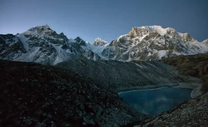
In order to reach Larkya La pass, the trek’s highest point, you’ll have to make your way through a number of different ecosystems, including farmland, bamboo, rhododendron, oak, and pine woods. This pass is located at an elevation of 16,500 feet. Pawar Peak (6,620m/21,720ft), Cheo Himal (6,820m/22,376ft), the Himlung pyramid (7,126m/23,380ft), Gyaji Kung (7,030m23,065ft), Kang Garu (6,981m/22,905ft), and Annapurna II (7,937m/26,041) can all be seen from the pass.

Highlights of Manaslu Base Camp Trek

  • Cross one of the highest passes in the world at Larkya La Pass at 5,106 meters
  • Spot wildlife species of Tahr (mountain goat), Agali (Blue Sheep), Pika (Highest Living Mammal), Himalayan Marmots, and even Snow Leopard
  • Spectacular panoramas of Manaslu, Cheo Himal, Ganesh Himal Range, Himlung Himal, Lamjung Himal, Nemjung, Gyaji Kang Guru, and Annapurna II
  • One of the popular restricted trekking regions with high altitude glacial lakes; four glaciers are mingled above Lamjung Himal
  • Soak into the lifestyle and culture of Nuri, ethnic habitant of the region
  • Explore the fascinating Tibetan influenced culture and festivals celebrated by Indo-Aryan Hindus like Magar, Gurung, Tamang, Burmese.
  • Rich in local multi ethnic biodiversity and natural scenery with captivating of Manaslu Conservation Area
  • Trails pass-through several farmlands; Budhi Gandaki River Gorge, forests of rhododendrons, oak, pine, bamboo, cedar, birch, juniper, and delightful meadows

Itinerary

We travel west from Kathmandu towards Pokhara, following the winding road over the valley rim and down alongside the Trisuli River. After crossing Trisuli River, we enjoy clear views of the Ganesh Himal and Shringi Himal as we pass through numerous villages before reaching our camp in a small village above the river at Liding.

Today we follow a road track of constant ups and downs through forest as we continue to head upstream along the Buri Gandakhi. We descend to the wide, sandy riverbed for lunch then continue along a winding mountain path overlooking the river. After crossing many suspension bridges, we stop in small village of Khorlabesi.

The Buri Gandakhi gorge is narrow with sheer cliffs on either side and the morning’s trail begins by following a cliff path along the east bank before passing hot springs at Tatopani and then crossing the Dodan Khola. Today we enter inside Manaslu Conservation area and we camp in a Rocky Valley above Buri Gandakhi.

Today will be an easy walk to Chisapani following the trails alongside scenic views of natural waterfalls and rustic villages.

Continuing on, we occasionally have to trek high above the river to skirt around narrow gorges that prohibit a path. Today we also have chance to meet a mules on the very narrow trail. The trail takes us through pine forest scattered with rhododendron.

We climb initially and then descend to cross a suspension bridge to the opposite bank. There are more riverside undulations and mani walls and chortens may be seen, signs of the distinctly Tibetan territory into which we are entering. The valley trail keeps to the northern bank below the village of Bih. Bih is known for its family of master stone carvers and along the trail today we see flat stones carved with intricate figures and stupas. Just past Bih we catch glimpses of the Shringi Himal and continue along the northern bank of the Buri Gandakhi until we reach the dominantly Tibetan village of Ghap for lunch. We then continue up through the forest densely vegetated with pine and birch to our jungle camp amongst the trees just before Namrung.

We descend to cross the Damonan Khola then ascend again along a narrow path through the forest to Namru then continue through the forest path past small Tibetan villages towards Ligaon. It is likely that we will encounter our first yak today and there is also a troop of monkeys who often come down to the river here to drink. We have uninterrupted views behind us of Ganesh and Baudha Himal range and to our right the Kutang Himal stands high as the natural border between Nepal and Tibet. Before us our first real mountain panorama opens up with the peaks of Himalchuli (7893m), Peak 29 (7871m) and finally Manaslu (8163m).

We cut diagonally across a rocky riverbed and climb a small ridge to a clearing. An amphitheatre of snow covered peaks including Manaslu. Manaslu North (7157), Peak 29 and Himalchuli surround us. The valley opens up and we continue along grassy slopes and small ridges which finally gives way to cultivated fields of Sama village. The trail takes us out of the grasslands and into wider territory as we skirt around some glacial moraine then descend to the riverbed. The view of Manaslu is superb today.

Today has been set aside for acclimatisation. There is an optional walk up the ridge below Manaslu to base camp (4500m), approximately 1500ft, in snow, to gain spectacular views of Manaslu, glaciers and lakes. Overnight: Wilderness camp

The trail takes us out of the grasslands and into wilder territory as we skirt around some glacial moraine then descend to the riverbed. Excellent views of the peak of Manaslu today. We soon reach the Tibetan Refugee village of Samdo, a wild place with a substantial village of some 200 permanent residents. Day 13 is a rest day. Relax and enjoy the surroundings or explore Lajyung Bhanjyang valley. Overnight: Wilderness camp

Day 12 :
Rest day

After a couple of stream crossings, the Larkya Glacier appears on the opposite bank. We steadily climb, skirting around the Sarka Khola to camp at a small brick hut at the base of the Larkya La (pass).

Soon after setting off today the unique shape of Larkya Peak becomes visible. The trail upwards is very gradual but at this altitude we take our time. It takes us approximately 5 hours to reach the pass, with the last section becoming quite steep but it is well worth the effort. The mountain vista to the west is incredible - Himlung Himal (7126m), Chap Himal, Gyaji Kang, Kang Guru (6981m) and Annapurna II (7937m). The descent from the pass is very steep across ice and scree as we follow the glacier. Progress is slow and careful but eventually we enter the valley of the Burdin Khola and continue to Bimtang and our camp for the night.

The trail now basically follows the Marsyangdi downstream, before entering a pristine forest of pine and rhododendron which during the spring months puts on a brilliant display of color. Keep your camera handy today as the views of the Himlung and Manaslu Himal are again spectacular.

Today we pass through few small villages where we meet the road goes to Annapurna circuit which is inside Annapurna conservation area. Tonight we will camp in the bank of Marsyangdi river with view of Natural water fall at Tal.

After breakfast we will be descending up to the village called Jagat and drive to Bhulbhule.

Today after breakfast we will directly drive from Bhulbhule to Kathmandu.

FAQs

Trek difficulty

The entire distance from the starting point to Manaslu Base Camp is around 177 kilometers. Over the course of several days, you will traverse an average of 15–20 kilometers on foot. The ups and downs you’ll face on this hike also contribute to its overall difficulty. Trekking along the Budhi Gandaki River can be treacherously steep at times. The ascent to Larkya La Pass is a strenuous one.

The Larkya La Pass, at an elevation of 5,213 meters, is the highest point of the Manaslu Base Camp Trek. As a result of the high altitude, some people may experience symptoms of altitude sickness. It might get chilly on the trails due to the wind. Considering these factors, it’s clear that the Manaslu Base Camp Trek is an arduous journey. You’ll need to be in good physical shape if you want to make it this far. You’ll need at least two to three months of training to get in shape for this journey.

Best Seasons

The months of September, October, and November are prime season for the Manaslu Circuit Trek. The Annapurna Range, including Manaslu, looks its best in the fall.

The Manaslu Circuit Trek is second most popular in the spring (March, April, and May). Manaslu Conservation Area’s rhododendron woodlands are particularly stunning during this time of year. Another reason spring is so well-liked is because it typically has light precipitation.

The Manaslu Circuit Trek takes you to an altitude of almost 5,000 meters, which means that during the winter months (December, January, and February), you could experience temperatures as low as -20 degrees Celsius. The monsoon season often occurs in the summer (June, July, and August), making the routes wet and muddy. Therefore, you must carefully pack and prepare for your travel throughout these two seasons.

People and Lifestyle

Atop the rolling slopes of the Gorkha District is where you’ll begin your trek to Manaslu’s base camp. Temperate nature with Hinduism, typical Nepalese people, average biodiversity, a green hill, and cultivated fields with fruits, vegetables, and crops can be found at the lower altitudes of the Manaslu hike. As you climb higher, you’ll notice that everything changes. Tibetan-sounding people who practice traditional Buddhist beliefs and customs. The Hindu shrine has been replaced by a Buddhist monastery complete with a Chorten, mani walls, and prayer flags. The availability of very remote farmland gives the impression of being stranded in the wilds, far from the taint of civilization.

Tibetan Buddhism has left its mark along this trail in a number of ways. Some of the monasteries you’ll see on your journey include Labrang (Lama’s Place) Gompa, Pungyen Nunnery, and the Kargyu-Pemba Chholing Gompa. Visit these temples to learn more about the local Buddhist culture. The neighboring mountains provide a stunning backdrop for these monasteries.

Heritage and landscapes

The hike to Manaslu’s base camp takes you through a wide range of landscapes. The terrain is challenging and oddly shaped. You’ll walk between 9.3 and 12.4 miles every day. Along the way, you’ll have to face some terrifyingly steep inclines that will put your stamina and patience to the test. The trail to Budhi Gandaki gorge is a challenging first leg of the hike. Much of your journey will consist of alternating uphill and downhill walking. It’s not easy to get across Larkya La Pass, which stands at 5,213 feet. In other words, it will be a serious challenge to your ability. Mindset is everything, so get ready for the challenges ahead.

Flora and Fauna

A handful of people and yaks can be seen along the way. The only safe thing to do when a yak is coming at you is to go to one side, toward the inside of the track, so as to avoid the cliff edge on the other side.

The Manaslu region is home to some of the world’s most stunning and severely endangered animals. There is a good chance that endangered species like the Red Panda and Snow leopard may steal the show in Manaslu. Additionally, to the grey wolf, Asian black bear, blue sheep, Himalayan musk deer, etc., there are approximately 110 species of birds, 33 species of animals, three species of reptiles, and eleven species of butterflies. Manaslu conservation area was established recently in an effort to preserve the region’s rich biodiversity.

Recommended Gears for the Trek

The Manasalu Basecamp Trek can be appropriate and pleasant if you are geared up with a proper packing list. Therefore, being prepared with the packing list prior to the trek comes in handy.

The necessary packing list for the trek are mentioned under the following points:

Clothing

  • Jackets (Windproof or Down)
  • Waterproof outerwear
  • Thermal wears
  • Woolen hat or cap
  • Pair of gloves
  • Shoes
  • Tracksuits and trouser
  • Trekking boot
  • Towel

Equipment

  • Bags
  • Sunglasses and sunscreen
  • Water bottle
  • Camera, binocular and mobile phones
  • Extra batteries or power bank
  • Water purifier tablets
  • Headlamp and torch
  • Trekking Sticks
  • Lighters
  • Whistle
  • Toilet papers and tissue papers

Conclusion

The hike to Manaslu’s base camp is one of the best and most well-known in the world. The allure of the land itself will engulf you. Treks to Manaslu’s base camp offer a glimpse into the old Tibetan way of life, as well as a wealth of cultural diversity and stunning scenery. The Manaslu area is a fantastic place to travel and get mesmerized.

Trip Reviews

0.0
Rated 0.0 out of 5
0.0 out of 5 stars (based on 0 reviews)
Excellent0%
Very good0%
Average0%
Poor0%
Terrible0%

There are no reviews yet. Be the first one to write one.

Write a Review

Your email address will not be published.

You can send your enquiry via the form below.

Manaslu Base Camp Trek